The Shimshal Flood
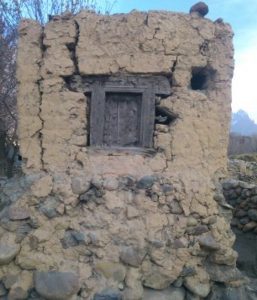
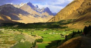
Shimshal is a village situated in the extreme north of Pakistan, on the eastern side of Hunza Gojal, sharing a very long border with China. Being a border village, Shimshal’s history is full of events of historical importance. The cyclical glacial outburst flood famously remembered in Hunza as the Shimshal Flood and called Verzhrav Flood by people of Shimshal, is one such historical event. This flood has a history of causing terrifying series of destruction throughout the length of Hunza, Nagar, and other downstream districts many times. The Shimshal floods have destroyed the economic resources of the area in the past, changed the social bounding, living conditions, and the geography of the area, especially in Shimshal, Passu, Hussini, Gulmit, and Ganish I Hunza while Nomal and Jutal in Gilgit District. Many settlers of the area moved to other parts of Hunza after losing their properties due to the floods. Exactly how many floods have came down the Shimshal Valley destroying large swathes of land is hard to tell without scientific investigation, but the local oral and documented history refers to several massive floods emanating from the Shimshal Valley.

There are four huge Glaciers – Yazgel, Yuks᷉hingẽrdan, Khũrdhopin and Verzhrav glacier in the east of Shimshal village. These glaciers move back and forth in routine, except for Varzhrav, which moves east to west at its endpoint. Jenny Jisser Hoooft (1922) writes, “The Verzhrav remains in our memory as the very worst glacier of the whole Kara-Korum”. Verzhrav is a combination of two Wakhi words Verz +Zhrav. Varz means the elliptical shape and Zherave means stream. Verzhrav is an elliptical shape valley with the largest glacier in Shimshal valley crossing through the southern part of Shimshal pass. This valley has been used as a winter grazing area and also for hunting ibexes and other wild animals right from the beginning of Shimshal history. Chasing ibexes, Qurban Karim and Dildar Baig, residents of Shimshal, reached the most interior part of the valley. Ismat Shah, Arab Khan, Muhammad Shafa and Juhar Ali interred to Shimshal pass using the glacier while no one has tract the glacier.
The explorers who discussed Verzherav valley and glaciers in the colonial era were, Francis Younghusband (1889), George Cockrill (1892) and (1893), Jenny Visser-Hooft and Philip Visser (1925), and Colonel Schomberg (1936) while mapping the Mũstagh area. Among them, Eric Shipton, Michael Spender and Angtharkay (1937) reached the eastern part of Verzhẽrav glacier, following the exploratory plan of Shipton and Tilman.
The valley has remained S̃hẽkorga (hunting place) of Shimshalis along with winter pasture. I remember when my uncle Qurban Karim and Dildar Baig went for hunting and came late due date due to chasing ibexes deep in the valley which created indecisions in my family. The domestic alnimal are still taken to the vally for sprin and autam grasing and yaks for winter grasing. Before any forign intervention in crossing the welly Two Shimshalies, Asmat Shah and Arab Khan, for the very first time traveling towards Shimshal Pass tracking through Verzhrav in the early 1970s, crossing through Arjolẽdhur to Chothpart while in the 1980s, Jauhar Ali and Muhammad Shafa explored another pass and intered into Wesẽm through Bakhtyoriedhur to inter Shimshal pass/ S̃hũwurt. In 1986 two Canadian Gelogist Barry Robert and Cameron Wak with two Shishalies Rajab Shah and Shambi Khan crossed Khudrapin Pass and entered Shimshal from Snow Lake.
The two neighboring glaciers in the west of Verzhrav (Yukšhingadan and Khurdapin) join each other at their endpoint moving south to north and from the destructive lake that, on the outburst, causes massive destruction.

Source: http://sergiujiduc.com/
As the glaciers of Khurdapin and Yukshingardan join each other at their tail, they strike the northern mountain and block the river flowing from the Verzhẽrav glacier. In more than one year period the lake stores a huge amount of water. According to local wisdom, the movement period of these glaciers is almost 20 years.
Muhammad Nayab and Ahmmad Ullah Baig, two local elders, narrated that the number of the years [taken for the lake formation] depends on the amount of snow and rain during the period. If more snow falls in the specific period then the glaciers move faster and form the lake one or two years before the usual time. However, if there is less snowfall, it takes more than twenty years for the lake to burst.
Local people also believe the amount of snow during the 20 years causes a large number of avalanches and the number of avalanches develops pressure on the movement of the glaciers.
The damages in 21st and early 20th centuries are not reported by local people but Kenneth Hewitt and Jingshi Liu 2010, reported as combined her, which is highly considerable for getting more information about damages and distractions. 1882 – 1884, 1890 – 1892 – 1893, 1901- 1904.

During the 20th century, the Verzhrav lake formed six times, with almost 20 years gap. The first erosion in the 20th century in Shimshal 1901 to 1904 which the local people could not report and reported by Kenneth Hewitt and Jingshi Liu. The next report was linked to the visit of Agha Abdul Samad, in 1921-22. The people from Shhimshal say that the riverbed of Shimshal was full of natural forest. The outburst of the lake washed away the whole forest along with the first settlement of Mamusing, the first person who reached Shimshal and irrigated the land, called Putdih/ Setenek, a small village about 18 km down the river on the left bank of Shimshal River.
People do not remember or know more about the destruction caused by the glacial outbreak. The accounts of the destruction, transferred orally over generations, are mixed up. Francis Younghusband, a British soldier and spy, has discussed the 1893 flood in his book published in 1926.
The third outburst of the 20th century occurred in 1942 reported by local people but as reported by Kenneth Hewitt and Jingshi Liu it of 1944 with huge destruction especially in Passu and Hussaini, two downstream villages. After this destruction, the riverside of Shimshal once again was full of natural forest and people had enough wood for daily uses. Continuous floods from 1960 to 1964, reported by local people and 1959 to 62 reported by Kenneth Hewitt and Jingshi Liu. According to the local oral accounts, swept the forest, irrigated fields, houses, orchards with fruit. Two water channels, Yishg᷉heriz and Risgine᷉ben, caused severe water shortages for fields in the valley. In the 20th century, it is considered the most destructive, leaving a huge negative geographical and economic impact on the villages especially Shimshal, Pussu, Hussaini, Gulmit and Ganish in Hunza and on many other settlements down the country.
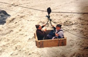
Very little human loss has been recorded probably because the residents of Shimshal were watching the movement of the glaciers and outburst of the lake and passing messages to the villages downstream warning them to live cautiously and leave risky places in advance to avoid losses. The volunteers from Shimshal were posted on different mountains from Yazghel to Avdegar mountain ranges to communicate messages, while volunteers from the rest of Gojal were responsible from Passu to Be᷉ldihil and then from the center and then lower Hunza passing messages to settlements downstream. These volunteers would inform the villagers by making fire at night time and smoke in day time indicating the lake burst.
I witnessed the Varzherav Lake from Yazghil in 1980 and 2000 but it did not destroy any village except some areas in Pussu and Hussaini on its way; the level of destruction was not like that of 1940 and 1960 or before the 19th century which made people migrate to Devdor and down the river in Seriqul. I witnessed its destruction in the 1960s which was terrifying and swiping whatever comes to its way.
Based on the above facts and figures, and drawing upon the local knowledge, I think the Khurdapin and Yuks᷉hingardan glacier might again block the Verzhẽrav River, forming a lake, in around 2040. If the burst of the lake is like that of 1960, then the magnitude of disaster will be double due to the availability of Ataabad Lake on the way. I am not creating a situation of frustration through this article but informing the government and organizations to study the glaciers in detail, and take precautionary measures. I suggest some specialist(s) visit and see the situation on the ground because rain and snowfall have increased in recent years.
I think the solution to avoid any destruction ether on KKH or local villages is required to construct drainage before the glaciers (Khũdhapin and Yuks̃hingẽrdan) will start moving downside their way and form the lake. It is possible by constructing an underground channel throughout the mountain on the right bank of the Verzhẽrav River opposite the Khũrdhoping glacier. If the measures will not be taken today then it would become hard while it will start forming the dame. As it will start forming dame then we will have only one option monitoring the movement and informing the government and local people settled on the riverside in Hunza and down the Hunza River, as we did previously.
The accounts of the Shimshal Flood presented by Kenneth Hewitt and Jingshi Liu is presented for you deeper view and decision making
1882 – 1884, 1890 – 1892 – 1893, 1901- 1904, 1922 – 1923, 1944, 1959 – 1962, 1978 – 1980, 1999 – 2000, 2017 – 2018
By Aman Ullah Maad

Totally agree that allot of effort is needed in this regard in the high mountains or Gilgit Baltistan as well…